Index of /weatherfax
Name
Last modified
Size
Description
Parent Directory
-
P_96hr_full_ocean_color_transparent_background.png
2025-07-01 00:30
157K
P_96hr_full_ocean_color.tif
2025-07-01 00:30
83K
P_72hr_full_ocean_color_transparent_background.png
2025-07-01 00:30
166K
P_72hr_full_ocean_color.tif
2025-07-01 00:30
80K
P_48hr_full_ocean_color_transparent_background.png
2025-07-01 00:30
164K
P_48hr_full_ocean_color.tif
2025-07-01 00:30
81K
P_sfc_full_ocean_color_transparent_background.png
2025-07-01 00:30
121K
P_sfc_full_ocean_color.png
2025-07-01 00:30
135K
Atl_Tropics_color_transparent_background.png
2025-07-01 00:30
70K
Atl_Tropics.gif
2025-07-01 00:30
81K
A_72hrbw.png
2025-07-01 00:30
95K
A_96hr_full_ocean_color_transparent_background.png
2025-07-01 00:30
179K
A_96hr_full_ocean_color.tif
2025-07-01 00:30
84K
A_72hr_full_ocean_color_transparent_background.png
2025-07-01 00:30
181K
A_72hr_full_ocean_color.tif
2025-07-01 00:30
88K
A_48hr_full_ocean_color_transparent_background.png
2025-07-01 00:30
206K
A_48hr_full_ocean_color.tif
2025-07-01 00:30
95K
A_sfc_full_ocean_color_transparent_background.png
2025-07-01 00:30
139K
A_sfc_full_ocean_color.png
2025-07-01 00:30
153K
A_sfc_full_ocean.png
2025-07-01 00:30
82K
PPVJ89.TIF
2025-07-01 00:30
66K
PPVO89.TIF
2025-07-01 00:30
65K
PPVM89.TIF
2025-07-01 00:30
67K
PPVK89.TIF
2025-07-01 00:30
66K
PPVI89.TIF
2025-07-01 00:30
66K
PPVG89.TIF
2025-07-01 00:30
65K
PPVA89.TIF
2025-07-01 00:30
69K
PPVE89.TIF
2025-07-01 00:30
61K
PYEK10.TIF
2025-07-01 00:30
21K
PYEI10.TIF
2025-07-01 00:30
21K
PYFK10.TIF
2025-07-01 00:30
21K
PYFE10.TIF
2025-07-01 00:30
21K
PWBI10.TIF
2025-07-01 00:30
24K
PWAM99.TIF
2025-07-01 00:30
26K
PYAA12.TIF
2025-07-01 00:30
29K
PYFI10.TIF
2025-07-01 00:30
21K
PWBM99.TIF
2025-07-01 00:30
23K
QDTM10.TIF
2025-07-01 00:30
26K
PYFA90.TIF
2025-07-01 00:30
25K
PYEA11.TIF
2025-07-01 00:30
27K
PPBE10.TIF
2025-07-01 00:30
25K
PYBA90.TIF
2025-07-01 00:30
26K
PYBA91.TIF
2025-07-01 00:30
25K
PYAA11.TIF
2025-07-01 00:30
24K
PPAE10.TIF
2025-07-01 00:30
27K
PPBA11.TIF
2025-07-01 00:30
12K
PYFE11.TIF
2025-07-01 00:30
12K
PYEE10.TIF
2025-07-01 00:30
20K
PYFK11.TIF
2025-07-01 00:30
12K
PYFI11.TIF
2025-07-01 00:30
12K
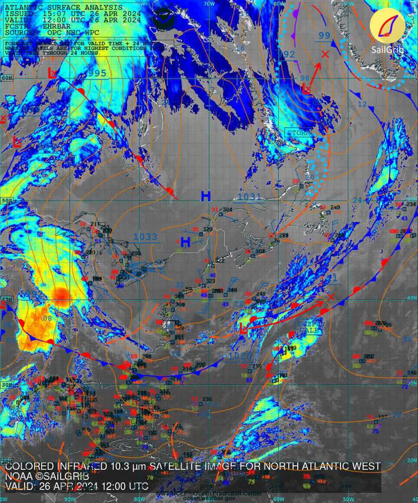
north_atlantic_west_analysis_infrared.jpg
2025-06-30 21:30
150K
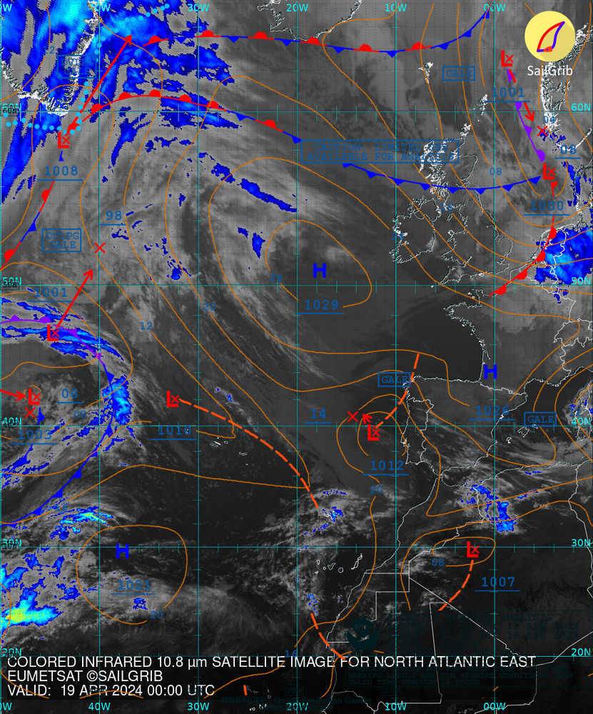
north_atlantic_east_analysis_infrared.jpg
2025-06-30 21:30
133K
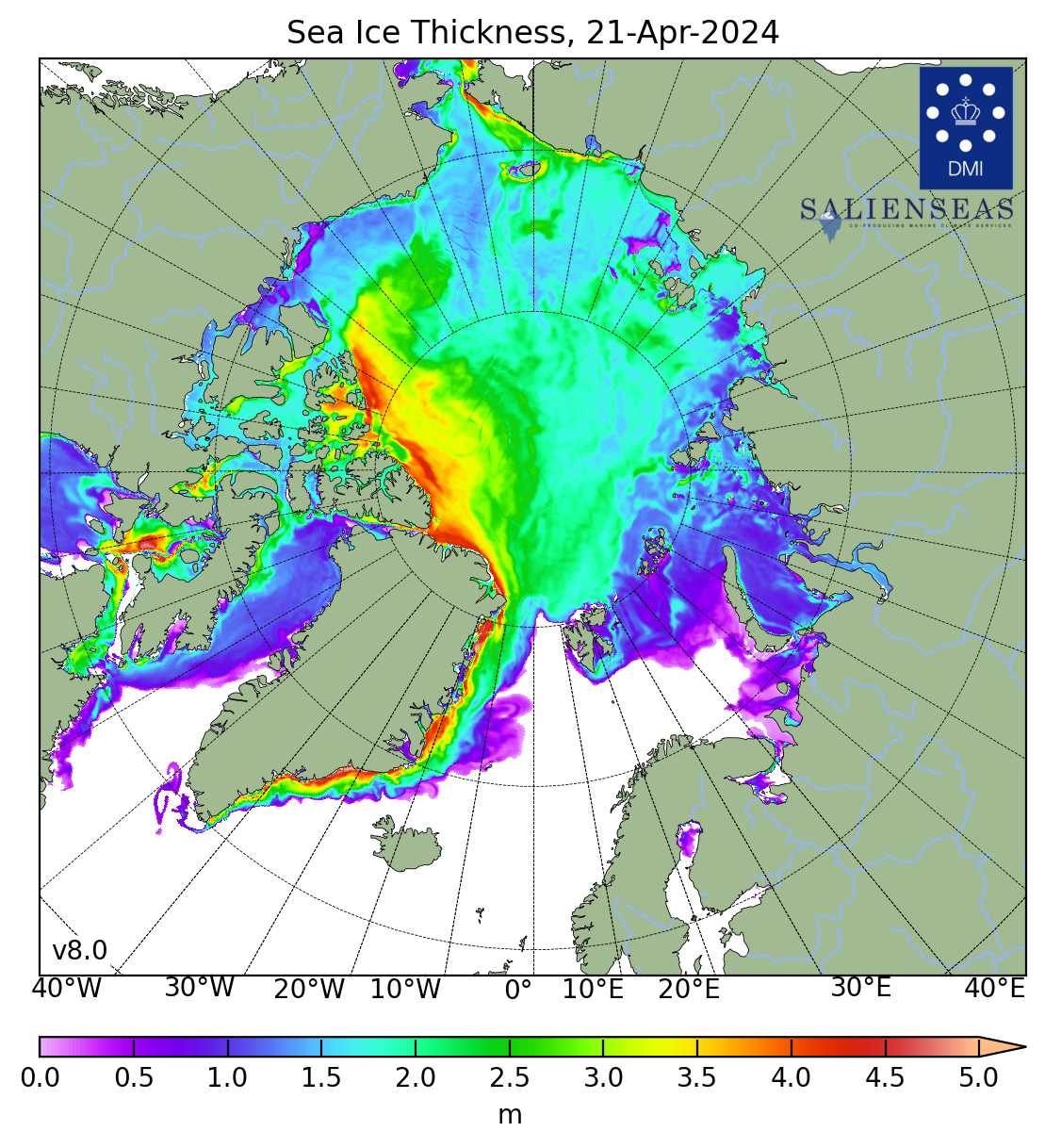
cice_map_thick_la_en_most_recent.jpg
2025-06-19 06:30
148K
south_atlantic_surface_analysis.png
2022-06-23 16:30
126K
fai_most_recent.png
2021-01-10 14:30
49K
Apache/2.4.29 (Ubuntu) Server at gribserver.sailgrib.com Port 80